![]()
![]()
1066-2000AD population growth table and graph
1349 - The Black Death - plague and recession
16th century on - population explosion industrial revolution
Kings and Queens of England 1066-2000
| Year | Aston | Anston | Dinnington | Harthill | Kiveton | Ulley | Todwick | TOTAL (est) | |
| 1080 | 60 | 20 | 20 | 60 | 60 | 10 | 40 | 270 | Domesday book est |
| 1379 | 700 | 500 | 43 | 400 | 100 | 90 | 100 | 1933 | Poll tax return |
| 1801 | 586 | 625 | 100 | 600 | 250 | 196 | 177 | 2534 | census |
| 1901 | 2000 | 1394 | 258 | 1400 | 2398 | 225 | 311 | 7986 | census |
| 1931 | 4500 | 2293 | 5000 | 1500 | 3000 | 200 | 350 | 16843 | census |
| 1991 | 14000 | 10459 | 7781 | 1834 | 5736 | 221 | 1639 | 41670 | census |
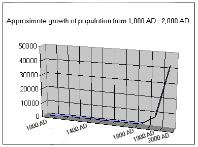
Or, to express it graphically:
Numbers last updated on 15/06/99 - next census 2001
It's obvious that the industrial revolution really kicked in during the 1800s with the opening of many collieries and the driving through of the railways.
The graph lurches upwards at around the 1900 mark when more large collieries opened at place like Dinnington and Thurcroft.
Note that the Domesday book estimate of 1086 (45,000 landholdings and 14,000 named locations, e.g. Herthill - today Harthill) has been rounded up to 1,000 people as the figure of just 270 looks, and probably is, too low. Certain categories of people would have been more or less recorded as property rather that as inhabitants and children and some women may not not have been counted at all (William's main aim was to establish the value of his new Kingdom rather than to count the population per se). Plus as the idea of the survey was the assessment of value for the collection of taxes then maybe the canny locals tried to keep the head count as low as possible!
Note also that some large villages\small towns are not yet included, e.g. Thurcroft.
The last ice age ended around 8-10,000 years ago with it came the retreat to the north of the ice sheets that buried this area under hundreds of metres of ice. Because so much water was locked up in ice, the sea level was much lower than today. The English channel did not yet exist and neolitic man was able to follow the retreating ice northwards from what is now mainland Europe to the location of this site. At Anston Stones and nearby Cresswell Crags neolithic remains such as pottery, flint arrow heads and tools, and cave paintings, have been found from those pre historic days when wolf and bear lived here.
For most of the long history of this area since the ice age the area has been heavily wooded (and was once part of Sherwood Forest), and/or agricultural in nature. The river Rother runs down its west boundary beyond which lie the Pennine range. To the east is are flatlands of Lincolnshire stretching all the way to the North Sea.
Around 3,500 years ago Celtic tribes from central europe settled the area. This raises the question of whether to regard the neolitic peoples as the 'true' britons' with the Celts as just the first of succesive waves of invaders? The answer possibly lies in modern DNA testing: A neolitic skeleton some 8,000 years old was unearthed in Cheshire and DNA tested - it shares some DNA with that of a local high school teacher whos' family came from the same area! It seems likely that each wave of settlers/invaders were ultimately as likely to wind up interbreeding with those already there, as killing or driving them away. I guess this question will be answered with future DNA surveys.
2,000 years ago this area was conquered by the Romans and for a while must have been the northmost point of the Roman Empire. Evidence of their presence is still to be found. Romano-British pottery has been found in Anston Stones wood. Also, near to Dinnington 2 jars containing over 1,500 roman coins were found in the 19th century - a fortune that was abandoned for over 1,500 years. Maybe they were abandoned due to the death of their owner in the unrest that bought the Anglo Saxons here in the political and military vacuum that followed the collapse of the Roman Empire? See also the article on the Ryknild Street and recent Roman finds.
In AD 419 (1,600 years ago) Anglo-Saxons
arrived from north Germany at the invitation of British chieftain
of chieftains, Vortigen, for defence against Pictish and Irish
marauders, or at least people who lived in present day Scotland and
Ireland which isn't necessarily the same thing. In the 600s (1,400
years ago) Christianity arrived in the area and the first of the
sites of many of the churches featured on the website were
established.
Under the Anglo-Saxons this area was part of the Kingdom of
Mercia.
From the 800s onwards Vikings conquered all of north England (the southern English Kingdom of Wessex remained Saxon).
The Vikings carved out the county of Yorkshire; A 3 county Viking kingdom with the capital at York (then Yorvik), with these villages in the counties south western corner. And so, for 200 years this corner of England was a hotly disputed province of Denmark! Incidentally one of the the first taxes ever to be imposed upon the inhabitants of these isles was called Danegeld (roughly Danish Tribute) and the villages area was part of Danelaw (Danes jurisdiction). This area was one of the places where Saxon and Danish domains met, and may have been the site of the Battle of Brunanburh in around 937AD, according to Davies in his history of the Isle it's commemorated in Celtic legend as the last chance they had to regain the mainland from the Saxons - although in truth it was a case of the various Celtic and Viking chieftains and lords (this was part of Yorvik) versus resurgent Saxon power. 50,000 warriors are reputed to have died in the most decisive battle for the control of the future history of the British Isles. There are 3 other candidate sites in the UK however.
1,000 years ago Normans conquered the place, they were also of Viking extraction who had conquered the Normandy (Land of the Norse) area when their kinsmen had been hacking out great swathes of Saxon territoty in north England. William the Conqueror claimed that he had a legitimate claim on the English throne. (Edward the Confessor, his cousin and King of England, died childless on Jan. 5, 1066. It is possible that Edward had promised William, Duke of Normandy, the throne). William by the way was an illegitimate son of a tanners daughter, and was also called William the Bastard (Guillame le Batard).
However, when Edward died, Harold, Earl of Wessex, had himself
crowned king. William decided to invade England to gain the throne.
By August 1066 William had assembled a force of about 5,000 knights
in 180 longships on the coast of Normandy. But the weather made it
impossible to sail until late September. Meanwhile, Harold made his
hold on the crown more secure by defeating an army led by the king
of Norway, Harald III Hardraade (who also claimed the throne), at
the battle of Stamford Bridge near to York (45 miles NE of the
villages) on September 25. Harold's battle weary and exhausted
warriors staggered south 250 miles in just 12 days to meet
Williams' knights. On September 27 William and his army were able
to sail. The two armies fought at Hastings on 14th October and
William won, and the rest is history. Unlike the history taught in
Schools though it was not a case of a French invasion of Saxon
England as much as the final phase of the Viking\Norse carve up of
Britain.
Whatever the politics of the age the Norman's duly conquered at
Hastings in 1066 and in 1069 fought their Norse rivals to gain the
Kingdom of Yorvik - including these villages. The ancient ties with
Scandinavia were weakened, and new ones with continental Europe
created, and the final ingredient was mixed into an inventive,
seafaring, and warlike nation that was to found an empire that,
with Scotland, Wales and Ireland briefly covered at its peak 20% of
the earths land area, some 800 years later (founding the U.S.A. on
the way). Whatever your political views you'd have to admit that it
was a very impressive and globally sigificant achievement.
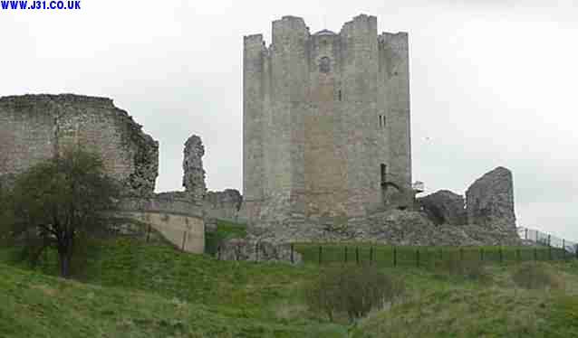
The Domesday book entry for Harthill starts Herthil in the
fee of Consibro [Conisborough]: For the Normans, much of this
area was in the fee of Conisbro and much of Consiborough
Castle still stands (below).
As far as the villages of this website were concerned the Normans also left a legacy of stone churches with Norman style components (previously churches were wood which does not survive the centuries well). William the Conqueror gave the whole area to one Roger de Busli. William also imposed the feudal system on his English subjects whereby everything was technically the property of the King, and the King had the right to reward his followers with land and property. And so, to reward his 20,000 or so knights he carved up England into areas that were his to grant, the smallest area being the manor, an area such as Laughton or Harthill. To this day there are manor roads and manor houses (not of Norman vintage though). The richest nobleman of all England was William de Warenne who had Harthill church built, he was as rich in 1080 as Bill Gates of Microsoft was in early 2000 (circa £50-55 billion according to the Times of London in 2000).
In 1349, this area, in common with all of the UK and Europe, was devastated by the plague or 'black death'. A staggering 50% of the population died and the event triggered a recession that lasted for around 60 years (which is how long the population and economic activity took to recover). This event was the equivalent of a limited nuclear war in its effects.
In the 16th and 17th centuries the aristocratic descendants of the Normans built many fine houses for themselves on their estates around here, and buried themselves inside the fine old churches: the hoi poloi got plots outside if they had the cash to buy one, a paupers grave if they hadn't.
Between 1530 and 1690 the population of England and Wales grew from 3 million to 6 million, yet economic growth was stagnating. Before this period the massive forests that covered most of the UK supplied wood and charcoal for domestic and industrial energy uses . But the forests were fast disappearing and the wood was running out; consequently its price was rising.
Coal was the answer, but critically it was poor for domestic uses, or to meet a huge pent up demand for iron smelting. Building houses with chimneys ameliorated the first problem, but not the second as the sulpher and other contaminants in coal ruined any steel made with it.
Then in 1640 a method of mass producing coke was devised (by brewers a few miles to the south of the area in Derbyshire) and the floodgates opened: cheap iron that didn't rely on ever more expensive charcoal. Demand for coal rocketed, and as this area has very extensive coal seams (there are stream beds made of coal in places) it started to become industrial as well as agricultural. A combination of the canals, railways, coal mining and steel making was to draw in thousands of workers to this area.
But before that was to happen there was a big problem: easy to get at surface coal was incapable of meeting demand and deep shafts flooded - even in 1700 there were no pumps capable of continuously shifting water from deeper mines. By 1720 though a coal powered steam pump (Nodding Donkeys') had been devised by Newcomen. Later advances by Watt around 1760 increased the depth from which water could be pumped and the late 18th century saw many coal mines open. There is good evidence that medieval 'bell pit' coal mines existed in Aston aleast in Jon Laynes article which refers to the 1940s.
The Chesterfield canal was driven though the area in 1760 and so bulk transport was available (the stone to make the Houses of Parliament in London were transported through the Kiveton\Aston\Thorpe section). The final major boost that mining needed was the opening of the railway in 1849. Whatever was dug up could be quickly and cheaply transported, and the steel works of Sheffield consumed vast amount of coal - The population really exploded. The 8 villages described here saw their populations rise from around 300 in 1100 AD, to 2,000 in 1600 AD to 8,000 in 1900 AD, and 40,000 by 1991 - an unsustainable rate of growth methinks. After the second world war there was a significant influx of Scots and eastern europeans such as Poles and Ukrainians seeking work in the local coal mines etc., and since the 1970s there has been a significant influx of 'visibly ethnic' i.e. African and Asian origin people into the area. The next census is in 2001 and the results of the last one are given on the Rotherham Council website ( www.rotherham.gov.uk).
The industrial workers such as the miners and steelworkers remained poor and often died young, while the large landowners often lived in considerable style. This fact was a major driving force behind the formation of the Labour Party and socialist politics at the end of the 19th century. Even by the late 1980's South Yorks was only half jokingly referred to as the Socialist Republic of South Yorkshire with many members of Tony Blair's Labour government having their power base in South Yorks, though they toned down or dropped the socialism stuff considerably in order to gain enough votes to be elected govt.in May 1997.
In Sheffield, 2 hours walk to the west, steelmaking technology was advanced from craft made cutlery and knives to mass producing megatonnes of steel plate and railway track. In 900 AD the cost of a sword was £30,000 ($50,000 US) in 1999 money, or so I was told by a swordsmith at the Yorvik centre in York - mostly the value of the steel - today better steel would cost about £30 ($50). The craftsmanship involved in the manufacture always retains its value as always.
By 1995 just about all of the mines had closed, only a couple of dozen 'superpits' throughout the U.K.. The area was a focus of the 1984\5 miners strike where it was Margaret Thatcher's government versus the miners, and the government won (they Tory govt. lost the previous industrial battle in 1973 after which the Ted Heath govt. was toppled). For now the UK is powered by nuclear, gas, and oil with coal an important, but small (<20%) part of the mix. Dinnington, Thurcroft and Kiveton alone lost over 3,000 jobs when they shut in the early 1990s which must have directly affected 15-20% of the local population.
The old pit head winding wheels are now set in concrete and
displayed as memorials at the entrance of Kiveton, Aston,
Thurcroft, and other mining towns. Huge colliery waste heaps
disfigure the locality in places, and house values are lower than
the national average, as are salaries. But in many places, good
quality housing is being built, and the best of the old stock is
being renovated and the worst demolished. Light industry and other
employment is becoming established as the villages economies start
a slow but noticeable regeneration, and coalmining drifts into the
history of the area, along with canals and aristocratic manors
(themselves an ancient relic of the Norman invasion).
The nearby Rother Valley Leisure Park is an excellent leisure facility for water skiing, sailing, mountain biking, fishing, etc. and was built in the early 1980s from a reclaimed open cast coalmine, talk about silk purse from sows ear - it was the site of the old waleswood colliery, and was strip mined twice in the 20th century.
Postscript; In 2000 I was emailed by by an emigre from the area (to Canada in the 1980s) who remarked after a trip to her homeland on the number of 'upmarket' houses, so maybe its not all doom and gloom circa 2001.
 As the places covered by J31.CO.UK are in England, the Monarchs of England were the
  monarchs of here. The exception being from 1649-1659 when it was effectively
  a republic of England under Cromwell.
House of Normandy              House of Stuart
1066-1087 William I            1603-1625 James I
1087-1100 William II           1625-1649 Charles I
1100-1135 Henry I              1649-1653 Commonwealth
Stephen                        1653-1658 Protectorate of
                                           Oliver Cromwell
House of Plantagenet           1658-1659 Protectorate of
1154-1189 Henry II                         Richard Cromwell
1189-1199 Richard I            1660-1685 Charles II
1199-1216 John                 1685-1688 James II-See Thomas Osbourne's plot against on harthill pages
1216-1272 Henry III            1689-1694 William (of Orange)and Mary
1272-1307 Edward I             1694-1702 William III (sole ruler)
1307-1327 Edward II            1702-1714 Anne
1327-1377 Edward III
1377-1399 Richard II           House of Hanover
                               1714-1727 George I
House of Lancaster             1727-1760 George II
1399-1413 Henry IV             1760-1820 George III
1413-1422 Henry V              1820-1830 George IV
1422-1461 Henry VI             1830-1837 William IV
                               1837-1901 Victoria
House of York
1461-1483 Edward IV            House of Saxe-Coburg
1483      Edward V             1901-1910 Edward VII
1483-1485 Richard III
                               House of Windsor
House of Tudor                 1910-1936 George V
1485-1509 Henry VII            1936      Edward VIII
1509-1547 Henry VIII           1936-1952 George VI
1547-1553 Edward VI            1952-     Elizabeth II
1553-1558 Mary I
1558-1603 Elizabeth I
![]()
![]()
Web design, content, gfx by Techasaurus. Page content copyright Paul Newbold 2010.