The Chesterfield canal runs from the river Trent at West Stockwith to Chesterfield. It is a navigable by narrow boats from the Trent to Kiveton Park as at Aug 2011.
The Chesterfield Canal, was built in the 1760s to carry lead ore and other minerals from the peak district to the Trent water system, and was a significant waterway when canals were the main bulk transportation systems, before the railways were built in the 1800s.
The opening of the Sheffield - Lincoln railway line in the mid 19th century was in direct competition to the canal. The railway line runs alongside the canal for about 5 miles from Kiveton to Worksop.
It was also used to carry coal and limestone from collieries around Stavely, Killamarsh, Kiveton, and quarries in places like Anston. Limestone for the Palace of Westminster was carried from Anston - top quality Permian Limestone outcrops in Anston. In the 1970s there were pretty complete lime kilns next to the canal south of Anston - we camped inside them as kids. They may have been used to make quicklime for use in building mortar, possibly for the explosion of housebuilding when all the local pits opened between 1860 - 1910. The kilns seem to have more or less collapsed by 2011 though.
In the 20th century with the coming of road haulage, and the collapse of the 1.5 mile Norwood tunnel circa 1903 (an engineering marvel of the 1770's), the Chesterfield canal ceased to be viable, and Chesterfield itself was now cut off from direct water access to the Trent and North Sea. the canal fell into gradual disuse, although it was the 1950s before the last commercial barge navigated parts of the canal from east of the Norwood Tunmnel to the Trent.
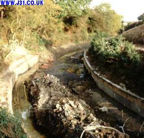
In 1990 only 26 miles from the Trent were navigable of the original 48 miles. In places it was a mud filled ditch.
My memory of the canal starts as a kid in the 1970s when it was a filled with reeds and silt up to and beyond Turnerwoood/Thorpe Salvin. It was navigable from the Trent to Worksop still. But during the 1990s the Chesterfield Canal was partially renovated with funds from a variety of sources.
The Chesterfield Canal Trust is currently running a campaign called Closing the Gap to re-link Chesterfield with the River Trent by re-opening the 9 mile or so stretch between Kivton and Stavely north of Chesterfield.
<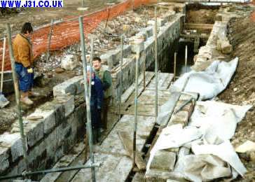
1997 - renovation underway at Turnerwood.
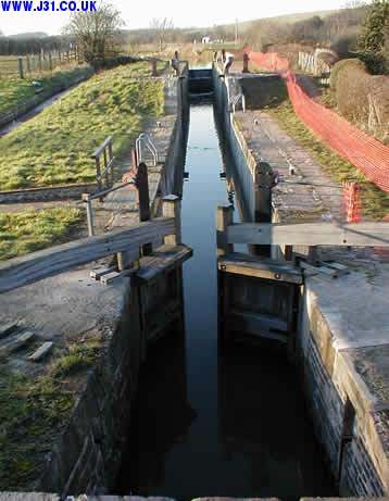
Above are the locks after renovation in Feb 2001.
The canal ran through a 1.5 mile tunnel under Tommy Flockton's, the old colliery site, under the present M1 motorway (which came 200 years later in about 1970), and out at Norwood near to the present Rother Valley Country Park. (If you aren't a local you probably won't know the name Tommy Flockton, the Ordnance Survey map makers don't, but he was a local farmer circa 1833 who's name lives on!),